You’re planning a trip to Jamaica and naturally, you want to know: where is Kingston located? It’s sitting proudly on the southeastern coast of the island. It isn’t just a dot on a map. Kingston is the cultural heartbeat of Jamaica, wedged tight between the towering Blue Mountains and the massive, deep waters of the world’s seventh-largest natural harbor. You can almost feel the bass of a reggae sound system thumping through the streets the moment you touch down. We’ve spent years navigating these waters, crafting premium private boat tours across Jamaica, and we know that understanding the island’s layout changes your whole vacation. Let’s break down exactly where the capital sits, how to get there from your resort, and where to find the absolute best coastal sailing.
Exactly Where is Kingston on the Map?
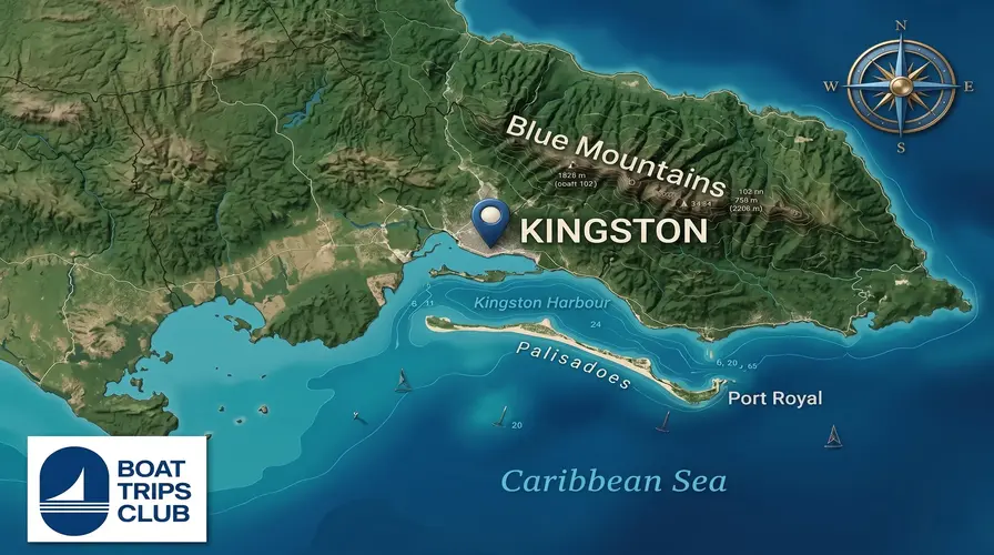
Kingston is located on the southeastern coast of Jamaica. The city is geographically bordered by the Blue Mountains to the north, providing a dramatic backdrop, and the Caribbean Sea to the south, featuring the seventh-largest natural harbor in the world. It sits within the County of Surrey.
The Blue Mountains to the North
Look north from the city streets, and you’ll see them. The Blue Mountains dominate the skyline. They don’t just provide killer views; they dictate the weather and the mood of the capital. Early mornings up there are thick with cool mist. You can smell the rich, roasted scent of world-famous coffee wafting through the air long before you reach the cafes down at sea level. The terrain is rugged and steep. That mountain range effectively creates a massive natural wall separating Kingston from the lush, tourist-heavy northern parishes. You feel the isolation and the sheer scale of the island’s geology when you stare up at those peaks.
The Caribbean Sea to the South
Spin around and face south. You’ll meet the water. Kingston Harbor is a deep-water sanctuary protected by the Palisadoes. That’s a thin, natural strip of sand acting as a giant breakwater. This harbor shaped the entire history of the island. Ships have navigated these tricky channels for centuries. According to the Jamaica National Heritage Trust, the nearby town of Port Royal was once the pirate capital of the Caribbean before a massive earthquake sank half of it into the sea in 1692. Today, you feel that heavy history in the salt spray whipping off the docks. The water here is deep, dark, and industrial. It’s highly functional for cargo but holds its own rugged beauty.
Driving Distances: Getting to Kingston from the Resort Hubs
Driving to Kingston from Jamaica’s major resort towns takes between one and four hours. The new North-South Highway makes the trip from Ocho Rios the fastest at under two hours. Traveling from Montego Bay or Negril takes significantly longer due to winding coastal and mountain roads.
Want the quick breakdown? Here are the drive times you need to plan for:
- From Ocho Rios: ~1.5 hours (via toll highway)
- From Montego Bay: ~3 hours (via coastal/inland mix)
- From Negril: ~4 hours (via the long southern coast)
Montego Bay to Kingston
People always ask how far is Kingston from Montego Bay when mapping out their itinerary. You’re looking at a solid three-hour drive, depending on traffic and how heavy your driver’s foot is. You leave the pristine, white-sand beaches behind and cut straight through the center of the island. The temperature drops noticeably as you climb through the hills of St. Ann and Manchester. It’s a gorgeous drive, full of lush greenery, roadside fruit vendors, and sharp turns. But if you’re chasing the ultimate luxury sailing experience, you might not want to leave the northwest coast at all. The waters up there are legendary. That’s exactly why our Montego Bay catamaran charters are constantly booked out. The reefs are vibrant, the water is glassy, and the rum punch flows ice-cold right on the deck.
Ocho Rios to Kingston
If you’re staying centrally on the north coast, reaching the capital is a breeze. Wondering exactly how far is Kingston from Ocho Rios? It takes less than two hours using the Edward Seaga Highway. This modern toll road slices straight through the island’s mountainous interior. You get jaw-dropping views of deep green valleys as you speed south. It’s the perfect day trip. You can grab a spicy Jamaican patty in the city center, visit the Bob Marley Museum, and easily be back on the north coast in time for a spectacular sunset catamaran cruise in Ocho Rios. The contrast between the concrete heat of the capital and the cool ocean breeze of an Ocho Rios evening is perfection.
Negril to Kingston
This is the marathon route. Negril sits on the extreme western tip of Jamaica, while Kingston hugs the southeast. You’re facing a four-hour road trip. The drive takes you along the rugged, less-developed southern coast. You’ll pass through sleepy fishing villages and dry, savanna-like landscapes. You can smell roasted cashews and pepper shrimp sold by vendors on the side of the road. It’s a fascinating side of the island most tourists miss completely. However, for a short vacation, spending eight hours in a car round-trip isn’t ideal. You’re much better off staying put and sailing the Negril coastline. Why? Negril’s Seven Mile Beach and the towering cliffs of the West End offer the absolute best sunsets in the Caribbean. You want a front-row seat on a luxury boat deck for that show, not a spot in a traffic jam on the Mandela Highway.

Coastal Tours & Water Culture Near the Capital
Kingston offers water excursions primarily focused around Port Royal and the nearby cays. Visitors can take short boat rides from Port Royal to Maiden Cay or Lime Cay for beach parties and snorkeling. However, luxury catamaran sailing is less common here than on the north coast.
Kingston might be a massive urban center, but its soul is tied to the sea. You just have to know where to look. Head out to the end of the Palisadoes peninsula, past the airport, and you hit Port Royal. It’s sleepy now, but the maritime energy is undeniable. Small fiberglass boats bob in the water, their engines idling, waiting to ferry locals and tourists out to the cays.
Lime Cay is the most famous. It’s a tiny speck of white sand and mangrove just off the coast. On a Sunday, it transforms. You’ll hear dancehall music blasting from portable speakers, smell jerk chicken grilling right on the sand, and feel the icy chill of a Red Stripe against your hand. It’s raw, authentic, and incredibly fun. The Jamaica Tourist Board frequently highlights this as a top local experience for a reason. The water is clear, and the vibe is purely Jamaican. But keep in mind, these are small boat runs. If you want a sprawling, luxurious vessel with a full crew, open bar, and massive sun nets, Kingston isn’t the primary hub.

Beyond the City: Why the Best Boat Charters are on the Opposite Coast
The absolute best boat charters in Jamaica operate on the northern and western coasts. Towns like Montego Bay, Negril, and Ocho Rios benefit from calmer waters, massive protected coral reefs, and favorable trade winds, making them ideal for premium catamaran sailing and snorkeling.
In our experience, geography dictates the quality of the sail. We love Kingston’s raw, unapologetic energy. But when it comes to dropping anchor in a pristine cove, the southeastern coast faces some tough geographical realities. The water inside the harbor isn’t ideal for swimming due to commercial traffic, and the open sea outside the Palisadoes can get incredibly choppy very fast.
The real magic happens on the north and west coasts. That’s where the island’s topography shields the shoreline, creating glassy, turquoise bays. We rely on the steady, gentle trade winds in Montego Bay to fill the sails perfectly. We depend on the massive, thriving coral reefs in Ocho Rios to provide mind-blowing snorkeling stops. We chase the uninterrupted horizon in Negril for golden hour sails. The infrastructure for luxury maritime tourism is built entirely around these calmer, clearer waters. You want the salt spray in your hair, the sun on your skin, and the smooth glide of a massive hull cutting through the Caribbean.
Ready for the Water?
So, where is Kingston located? It’s sitting right at the geographical and cultural center of Jamaica’s southeastern edge. It’s a city of immense contrast—steep mountains plunging into a deep, historic harbor. You should definitely experience its music, its spicy street food, and its deep history. Walk the loud streets, hike the quiet hills, and take a quick skiff out to Lime Cay. But when you are ready to trade the concrete heat for an icy cocktail and a sprawling sun deck, head north or west. We’ll be waiting. Book your next premium sailing experience with Boat Trips Jamaica and let us show you the absolute best of the island’s coastal waters.
Frequently Asked Questions About Kingston’s Location
Many travelers have specific questions about flying into and navigating Jamaica’s capital. Kingston is serviced by the Norman Manley International Airport, which sits on a peninsula directly across the harbor from the city center, offering easy access to the southeast coast.
Which airport do you fly into for Kingston?
You’ll fly into the Norman Manley International Airport (KIN). It sits right on the Palisadoes peninsula. The approach is spectacular. You fly low over the Caribbean Sea, feeling like you’re going to land right in the water before the runway suddenly appears beneath the wheels.
Is Kingston considered a beach town?
No. It’s a major commercial and cultural city. While it sits directly on the water, there are no white-sand lounging beaches within the city limits. You have to take a boat out to the offshore cays or drive out to parishes like St. Thomas to find proper beach spots.
Is Kingston in the north or south of Jamaica?
It is firmly on the south coast. More specifically, it anchors the southeastern corner of the island. This specific placement gives it a drier, hotter climate compared to the lush, rain-fed northern coast where the major resorts are located.